
Regents Canal: Bridges


Regent's Canal passes under approximately 40 bridges on its route through north London. A selection of the bridges located between Little Venice and Camden Lock will be included here.
Bridge No. 3c: Steel (or wrought iron) and cast iron bridge at Little Venice, made by Francis Morton and Co.
Bridge No. 8, south west of Macclesfield Bridge: This bridge serves a path connecting Prince Albert Road (near Chalbert Street) with Regent's Park. Its construction is unusual, having three cast iron arch ribs, springing from cast iron plates on the masonry abutments, with brick vaulting between the arches, and brick and stone construction above the arches, surmounted by cast iron railings. When Regent’s Park was laid out from 1811 the lake was supplied by the Tyburn Brook. After the Regent’s Canal was built, a small aqueduct carried the stream into the Park over what is now Charlbert Bridge.[1]. So, Bridge No.8 may have been built as an aqueduct, presumably combined with a footbridge, but there is conflicting information.
An 1823 list of the altitudes of certain streets above the highest water on the Thames gives the highest 'At the road on the north side of the aqueduct crossing the Regent's Canal 102ft 6in.[2]
An 1837 map shows a stream, presumably Tyburn Brook, running south from Belsize Park, passing under Portland Town, then apparently passing under the canal close to Macclesfield Bridge, and entering the lake in Regent's Park.
An 1848 article states 'Likewise for the restoration of two other improperly stopped and important thoroughfares, viz., that which, by ancient right, should lead from Portland Town into the Regent’s Park, by means of the aqueduct foot-bridge over the Regent’s Canal; ...'[3].
The 1848-50 O.S. Town Plan shows a footbridge, with no indication that it might be an aqueduct.
1913: 'REGENT'S PARK and PRIMROSE HILL. Interesting Lecture by Mr. A. D. Webster. (Continued from last week ) When the Regent's Canal was being made (1812-20) the waters of the Tybourne were conveyed in a temporary manner across the cutting near the North Gate in a wooden trough, of which a drawing has been preserved. With the making of the canal the upper waters of the Tybourne were entirely cut off. ...'[4]
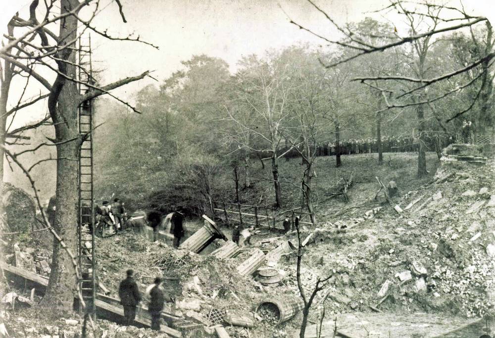
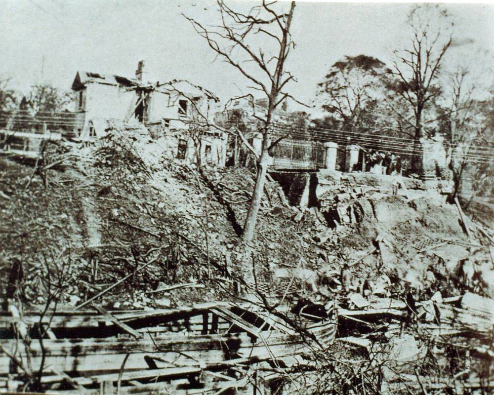
Macclesfield Bridge (also known as the North Bridge). On 2nd October 1874 at 04.55, a barge carrying gunpowder exploded, destroying the bridge and killing three crew members. The bridge was rebuilt using the original Coalbrookdale Co fluted iron columns. It is also known as "Blow Up Bridge". Contemporary photos of aftermath of explosion here and here[5]
Bridge 10: A cast iron arch bridge west of Broad Walk Bridge, providing access within London Zoo. The maker is unidentified, although the castings appear to be identical with those of Broad Walk Bridge (apart from the absence of the maker's details). It was designed by John Fowler, and described and illustrated in 'Engineering' in 1866.[6]
Broad Walk Bridge: Cast iron footbridge made by Grissell in 1864, which takes The Broad Walk over the canal. It replaced a suspension bridge.
Bridge No. 12 is by R. Masefield and Co.
Gloucester Road, Bridge No. 16: The dominant part of the bridge is of brick arch construction, but there is an interesting extension on the western side. It has cambered cast iron beams supporting flagstones. The outermost beam is evidently of recent construction, being reinforced concrete, with apparently old iron castings bolted to the face. above the beam is a dressed stone and brick parapet.
Railway Bridges, Nos. 17, 18, 19: Riveted plate girder bridges carry railway lines to Euston Station. These bridges are by no means as interesting as the 1837 bridge which they replaced in 1923: they were of a peculiar design by Robert Stephenson or Charles Fox, and the nearest comparable survivors of that type are Mills Hill Bridge, Chadderton and Todmorden - Gauxholme No. 2 Viaduct. It appears that the 1837 masonry abutments below girder level have survived (see photo). Note the flared centre pier: this shape can be seen in a contemporary drawing of the original bridge[7].
The Encyclopaedia Britannica, Vol. 12 (1856): 'It is composed of three main ribs of cast-iron open panel work, whose outline is parallel, but which includes an arc extending to its extremities of length and depth, and intersecting the vertical bars which form the panels. The span is 50 feet and the height of the ribs 10 feet. The section of each rib is in the form of a hollow rectangle 2 feet 11 inches wide, and the space between its sides is filled with diagonal bracing-frames 5 feet 10 inches apart. The railway is carried by cast iron girders of the fish-bellied shape, 28 feet between bearings and 1 foot 10 inches deep in the middle; they are suspended from the bracing-frames in the main ribs by wrought-iron suspension rods 2 1/2 inches diameter; there being sockets in the bracing-frames to receive their upper ends, and in the ends of the cross-girders to receive their lower ends.
The centre main rib performs double duty; and its bracing-frames have double sockets, and carry two suspension rods. In addition to the ribs themselves in resisting the strain of the load there are longitudinal tie-bars under each rib, there being four under each outside rib in a horizontal row, and eight under the centre rib in two horizontal rows. These tie-rods are secured to the bearing ends of the main ribs, and are in three lengths, each united by sockets, gibs, and keys. Upon the cross-girders are oak sleepers for the rails; and the entire space between the rails is filled in with cast-iron plates perforated in the form of trellis-work. The outsides of the outer ribs are ornamented with cast-iron mouldings and fret-work. This bridge is of very bold design and certainly a novelty as regards construction.'[8]
Camden Lock: Interchange Basin footbridge, No. 21: Cast iron footbridge over the entrance to the Interchange Building at Camden Lock basin, made by Joseph Deeley and Co (Newport). See here for an interesting account of the Interchange Building. At some point it became a bowstring bridge by the addition of slender tie bars, attached to the cast iron beams via bolted-on fabricated brackets. One source gives a date of c.1856. However, it is considered more likely that it dates from 1846, when alterations were made to the towpath in this area.
Roving Bridge at Camden Lock: Bridge No. 22, also known as Hampstead Road Lock Bridge. This is a rare example of an cast iron arch bridge with wrought iron tie bars fixed at the top of the parapet.
Camden High Street Bridge, No. 24: Also known as Hampstead Road Bridge or Camden High Street Bridge. Constructed from riveted wrought iron plate, with cast iron capping on parapet and restrained cast iron decorative panels on the girder faces.
The bridge is more interesting than might first appear. For more information, see Hampstead Road Bridge. In brief, the present iron bridge was built in 1876 to replace a masonry bridge built in 1815. One of the 1815 keystones is preserved in the 1876 bridge. Two of the girders served as gas mains, and the bridge was damaged by a gas explosion in 1881.
Royal College Street Bridge, No. 28:
Grays Inn (or Grey's Inn) Road Bridge (also known as St. Pancras Way Bridge and King's Road Bridge), No.29. The Contractor was Stephen Kavanagh. Thomas and Taylor of Victoria Street were the Engineers. Eastwood, Swingler and Co provided the steel work.[9] The bridge was opened on 22 July 1897, and replaced a brick skew bridge shown in the 1870 O.S. Town Plan here. As the photos indicate, numerous riveted members make up a very strong and rigid structure. Complex too, as a result of the amount of skew changing from one end to the other.
Bridge 31. This skew bridge carries Camley Street (formerly Cambridge Street) over the canal, just west of the St Pancras Railway Station bridges. Of plain appearance, its exposed cast iron beams indicate that it is probably much older than it appears at first sight. The 1871/4 O.S. Town Plan names this as 'Oblique Bridge', with no street name. It appeared to serve only the Midland Railway Goods Depot. The St. Pancras Workhouse was immediately south west of the bridge. The bridge is probably the one referred to in this brief Regent's Canal Co Report: The oblique bridge, at Agar town, St. Pancras, has been re-constructed, at a cost of £1,810 17s. 7d.[10]. The previous oblique bridge had 'failed'.[11]
See Also
Sources of Information
- ↑ [1] Friends of Regent’s Park & Primrose Hill - Water supply to Regent's Park
- ↑ English Chronicle and Whitehall Evening Post - Thursday 11 September 1823
- ↑ Morning Advertiser - 6 December 1848
- ↑ Marylebone Mercury - Saturday 26 April 1913
- ↑ [2] Friends of Regent's Canal website
- ↑ [3] Engineering, 6 July 1866. pp.4 & 5
- ↑ [4] 'Railway practice: A Collection of Working Plans and Practical Details of Construction in the Public Works of the Most Celebrated Engineers Comprising Tunnels and Tunnel Fronts, Turnpike Road Bridges...' by S. C. Brees, 1838. (Details of Robert Stephenson's 1837 bridge which carried the London & Birmingham Railway over Regent's Canal near Chalk Farm)
- ↑ [5] Tring Local History: Notes and Extracts on the History of the London and Birmingham Railway Chapter 9
- ↑ St. Pancras Gazette - Saturday 24 July 1897
- ↑ Herapath's Railway Journal - Saturday 5 June 1852
- ↑ Morning Herald (London) - Thursday 5 June 1851